Groundwater & Stratigraphic Analysis
During a resistivity survey, a direct current is introduced into the ground through two current electrodes inserted in the ground surface. Potential electrodes measure the potential difference, allowing us to compute the resistivity of the corresponding subsurface medium.
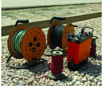
By utilizing state-of-the-art signal averaging resistivity-measuring equipment (SAS-4000), we ensure data accuracy and reliability. Our surveys use the Schlumberger array, providing a close approximation to the potential gradient at the center of the array for deep subsurface mapping.
What is an Electrical Resistivity Survey?
An Electrical Resistivity Survey (ERS) is a non-invasive geophysical investigation technique used to characterise the subsurface by measuring how strongly different earth materials resist the flow of electrical current. Every geological formation � whether saturated sand, fractured rock, clay, or dry gravel � has a distinct resistivity signature. By mapping these signatures across a site, Geo-Studies can produce a detailed cross-section of the subsurface without a single drill hole, saving clients time and money before committing to a borehole programme.
The technique is particularly powerful for groundwater exploration because water-bearing aquifers typically exhibit low resistivity values compared to dry or consolidated formations. A well-executed ERS campaign can pinpoint the depth, thickness, and lateral extent of a productive aquifer with a high degree of confidence, giving drilling teams the precise target coordinates they need to maximise yield and minimise dry-hole risk.
Schlumberger Array Methodology
Geo-Studies deploys the Schlumberger electrode configuration as its primary field methodology. In this arrangement, four electrodes are placed along a straight line: two outer current electrodes (A and B) inject a controlled direct current into the ground, while two inner potential electrodes (M and N) measure the resulting voltage difference. As the current electrode spacing is progressively expanded, the depth of investigation increases, allowing the survey team to build a vertical electrical sounding (VES) curve that represents the resistivity layering from the surface down to the target depth.
The Schlumberger array is preferred over other configurations � such as Wenner or dipole-dipole � because it offers a superior signal-to-noise ratio at large electrode spacings, making it ideal for deep aquifer investigations in the alluvial plains of Sindh and Punjab where target depths can exceed 200 metres. The compact inner electrode spacing also minimises lateral inhomogeneity effects, producing cleaner sounding curves that are easier to interpret with confidence.
SAS-4000 Equipment and RESIXP Software
The ABEM SAS-4000 Terrameter is the instrument at the heart of every Geo-Studies ERS campaign. This microprocessor-controlled resistivity meter delivers automatic signal averaging, stacking, and self-potential compensation, ensuring that field measurements are repeatable and free from electrode polarisation artefacts. The SAS-4000 can operate across a wide range of ground conditions � from the highly conductive saline soils of coastal Sindh to the resistive hard-rock terrain of Balochistan � without requiring manual gain adjustments.
Field data collected by the SAS-4000 is transferred to the office for quantitative interpretation using RESIXP, a professional inversion software developed by INTERPEX USA. RESIXP fits a theoretical layered-earth model to the measured apparent resistivity curve using an iterative least-squares algorithm, reporting the true resistivity and thickness of each subsurface layer along with a root-mean-square error (RMSE) value that quantifies the quality of the fit. Clients receive a full interpretation report that includes the VES curves, layer models, and a recommended drilling depth and casing programme.
Aquifer Detection and Subsurface Mapping Applications
The primary application of ERS at Geo-Studies is groundwater aquifer detection for industrial tube well projects. Before a client invests in a deep borehole � which can cost several million rupees � an ERS campaign costing a fraction of that amount can confirm whether a productive aquifer exists at the site, estimate its depth and thickness, and assess the likely water quality based on resistivity values. This de-risking function is especially valuable in areas where groundwater conditions are poorly documented or highly variable.
Beyond groundwater, ERS is also used for geological mapping, contamination plume delineation, cavity detection, and foundation investigation. In construction projects, a resistivity survey can identify zones of weak or waterlogged soil that would compromise foundation integrity, allowing engineers to redesign before breaking ground. In environmental projects, resistivity contrasts between clean and contaminated groundwater can be used to map the extent of a pollution plume and monitor remediation progress over time.
Industries Served Across Pakistan
Geo-Studies has delivered ERS campaigns for a wide range of industries that depend on reliable groundwater or require detailed subsurface knowledge before construction or drilling. Textile mills in Karachi, Faisalabad, and Lahore rely on high-volume tube wells to supply process water for dyeing, washing, and finishing operations; an ERS survey ensures the borehole is sited on the most productive aquifer zone. Pharmaceutical manufacturers require water of consistent quality and quantity for formulation and cleaning-in-place (CIP) systems, making pre-drilling geophysical investigation a standard part of their site development process.
Food and beverage producers � including bottling plants, dairy processors, and edible oil refineries � face strict regulatory requirements on water source documentation, and an ERS report provides the independent technical evidence needed for environmental compliance submissions. Construction companies and real estate developers use ERS to characterise site geology before piling or deep excavation, reducing the risk of unexpected ground conditions that cause programme delays and cost overruns. Government infrastructure projects, including irrigation schemes, rural water supply programmes, and industrial estates, routinely commission ERS surveys as part of their feasibility studies.
Geographic Service Area
Geo-Studies operates ERS survey teams across all four provinces of Pakistan. In Sindh, the team is based in Karachi and regularly surveys sites along the Indus alluvial plain, the coastal belt, and the Thar Desert fringe. In Punjab, surveys are conducted in the major industrial corridors of Lahore, Faisalabad, Gujranwala, and Sialkot, where the deep alluvial aquifer system supports intensive industrial water demand. In Khyber Pakhtunkhwa, the team has experience working in the Peshawar Basin and the piedmont zones where alluvial fans create complex aquifer geometries. In Balochistan, ERS surveys are used to locate fractured-rock aquifers in the hard-rock terrain of the Makran coast and the Quetta Valley.
Advanced Logging Techniques
Integration of Neutron Log and Photoelectric Log data to determine strata nature and hydrogen-bearing fluid content.
Computer-Aided Evaluation
Data interpretation using INTERPEX USA software (RESIXP) for high-resolution layer modeling and RMSE verification.
Aquifer Detection
Precise estimation of ground water electrical conductivity to identify sustainable water sources for industrial use.